2013 Preliminary Start List…

We’ve got 36 so far. Some familiar faces, and a new crew.
Check it out here.
2013 Preliminary Start List…
We’ve got 36 so far. Some familiar faces, and a new crew.
Check it out here.
Posted in stagecoach info
Tagged 2013 Stagecoach 400, Stagecoach 400, the next generation
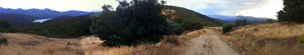
Mark Allen of Phoenix is out on his second day of his Holiday Time Trial on the 2012 Stagecoach 400 route.
He’s joined by Andrew Hoyer of Bakersfield, and one other rider.
Mark’s tracker is registered on the Trackleaders page and can be followed in real time here.
The riders are carrying both the old route file, and the new one. Mark’s ITT will be on the old route.
Andrew stopped in the shop Friday to talk route details and joined us for beer (bravo!) and tacos at the Lumber Mill. They all joined up and departed early Saturday morning.
They made good time through Coyote Canyon down to Borrego Springs, and appear to have spent their first night in Fish Creek wash, near Split Mountain.
Conditions in the wash are likely good, with the area having received rain recently and likely not *too much* OHV traffic. The mountains have some snow, especially on north faces. Overnight temps at elevation have been in the upper 20’s and low 30’s. Brrr!!
We’ve all been waiting patiently for the rest of the cues and the GPS track so we can start planning out the details of the ride.
What’s taking so long?
We’ve changed up the route; essentially turning it from a counterclockwise loop to a clockwise loop. But that rabbit hole is a little deeper than that might sound.
How come it’ll be going the other way?
We want to offer up the best possible dirt touring route possible, with the best representation of our little slice of Southern California. Like one of those routes the Adventure Cycling Association has. In that vein, we will now get to ride Palm Canyon and later, Noble Canyon. Both are Southern California classics.
What are the practical differences?
The route is a bit harder, and a bit more mountain bike-y.
What had been climbs are now descents, and vice versa. The route will start with the “desert” section, which means at one point the route will take you from below sea level (Salton Sea) to nearly 4k ft on Pinyon Mountain, by way of some beautiful but sandy roads. (Fish Creek Wash in the Anza Borrego State Park) We will climb Oriflamme Canyon (the stuff of legend) into the Cuyamacas & Lagunas. The addition of these two singletracks and the reversal of Oriflamme & Fish Creek wash are the most significant changes your legs will notice.
Does this affect the mileage?
It might make the route a bit shorter, since we’ll descend from the San Jacintos further south.
So when will the route be set up and ready?
Soon. Promise! We’ve got 200 miles of the clockwise route mapped & cues’d, and need to get the reverse track set for the “first 117” you’ve already seen and some of the urban/San Diego Bay area. Hopefully the whole shebang will be done inside of two weeks.
We’ll be posting more info on the route, the cues, and SPOT registration here.
 A very early start list has been posted and it’s going to be an exciting ride with all the usual suspects! Check it out here. We will be updating it weekly and sending out notifications on the blog, for those that are subscribed. Enjoy!
The route is only 90-95% finalized at this time, but we wanted to go ahead and announce the event to give plenty of time to prepare.

We will be gathering and publishing the GPS route and cue sheets here as soon as possible. Until then, a rough descriptor of the route will get your gears turning:
Leave from Idyllwild, CA on Friday April 27th
– ride to Warner Springs by way of the California Riding and Hiking Trail & Lost Valley road. Some great cafes & roadhouses in this area.
– approx 14 miles of pavement to Mesa Grande rd.
– Black Canyon rd to Ramona
– San Diegito River Trail (flat tire city)
– Lake Hodges (fun singletrack, Mexican food)
– Torrey Pines State Park… bike paths
– urban area through San Diego into Balboa Park, San Diego Bay- dip your toe in the water
– east via bike paths and dirt toward Alpine, Descanso
– climb into the Cuyamacas
– doubletrack through the mountains
– descend Oriflamme Canyon
– pavement on S-2 to Pinyon Mountain rd.
– headlong into the Anza Borrego desert, Fish Creek wash. Beautiful country.
– narrow gage railroad bed to Kane Spring
– around the southern tip of the Salton Sea via agricultural roads
– more gravel road where possible to Niland, near Salvation Mountain/Slab City.
– long stretch of canal access road and railroad access road to Mecca
– past the dinosaur from Pee Wee’s Big Adventure
– through the Desert Cities. Lots of 50’s modern history here.
– into the San Gorgonio Pass Wind Farm
– up and around back into the San Jacintos and Idyllwild.
")


