Category Archives: Reading Material

2011 San Jacinto Enduro & Moustache Ride

Grow for the gold…
Not fast enough to win? Maybe you’re swarthy enough to look good trying.
All Enduro racers will automatically entered into our ancillary moustache competition. Primes may or may not be offered on course for creative and original nose neighbors. Awards will be given apres ride by a panel of female judges for the very best mo’.


Loop 2 ride

We’re unofficially pre-riding Loop 2 Saturday, October 1st. 

Meet at Hub Cyclery at 8am Saturday. Come prepared to ride Loop 2 plus a bit of May Valley trails between the shop and Garner Valley. Social pace.


Info! … 2011 Enduro FAQ

By popular demand, we’re sharing some info with y’all dedicated Enduro fans. 

First off, if you want to ride: drop a line to sanjacintoenduro@gmail.com to RSVP. Consider this blog post the official “Game On” for the RSVP race. But please read the FAQ below first. Shit!

FAQ: 

What time do we start riding?
6am! Yeah, like cold and dark o’clock.

 Will people be camping? Where?
Yep, the last two years we’ve had camping at the Start/Finish area. It’s free. But last year it was friggin’ cold. Maybe not as bad this year? Dunno… cross your fingers. The camp area is easy to get to by common road vehicles, ie, you don’t need 4wd. The brave will carry on festivities well after sundown the night before.

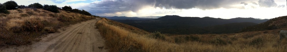
What’s the course like?
It’s tough. about 78 miles and maybe just shy of 11,000 feet in climbing for the whole shebang. We have two courses; everyone will do the 48 mile Loop 1, only the brave will go on for Loop 2. Most of the route is doubletrack, but you’ll need to be on your game for the singletrack sections. (maybe 20 miles?)

When do we get the cues?
Soon. RSVP to sanjacintoenduro@gmail.com first and be patient. We’re changing the course a little from 2010 and need to rework it. And since you ain’t payin’ us to do it, we ain’t in that big of a rush. Give it a week or so.

Do you have GPS files?
Hell no. We provide the route info, cues, and time tabulation. Nothing else. If you think a GPS route will be beneficial- as it very well may be- it’s up to you to build it out yourself. Consider it your “edge.”

Since it’s free, can I just RSVP and wait a while to decide if I’ll show?
Hell no. Be brave, commit to this ride, and spend the next 50-some days hardening up. You might not be able to harden up that fast? Too bad, you still need to come get your suffer on.

Will you do a pre-ride?
We’re talking about doing a pre-ride of Lap 1 maybe the weekend of Sep 24th or Oct 1st. Let us know which date you might be interested to join in.

Do you cap the field? How come?
Yes, we have been capping the field at 40 riders. That’s a reasonable number to garner a tough, solid field and still be well within legal limits to host the event without a permit. It’s free, ya know… we want to keep it that way. Phantom riders will be tarred & feathered.


More on Morris Creek singletrack (Loop 2 Addendum)

Be advised: Morris Creek singletrack is the roughest trail on the course. Some of the roughest trail near Idyllwild for that matter.

Also, in case you’re still not clear on this trail’s context within the main maps, follow the candy trail:

Google Maps

We had a question this morning to clarify the  Loop 2 Addendum:

If you zoom out a bit, or pan the map to the northwest, you’ll see a pin. This corresponds to the start of the Wagon Wheel section, marked on your cues. The second pin marks the start of the Morris Creek singletrack.

If you’re not familiar with Google Maps, fiddle with it a bit and check out the map in different views. Satellite and “terrain” (under “more” in the map section) can be very helpful.

Mileage Cues Clarification

The cues are written for a zero mileage point at the start of 6S13… though we’re actually riding a bit before we arrive at it, this highway mileage isn’t reflected on the cues.

Zero your computer at 6s13 and you will match the cues.

Tentative Route Mapped

We have the course broken down into two loops

… which total about 70 miles, 11,000 ft of climbing.

The first loop leaves from the Lake Hemet Campground at O-Dark Thirty on race day… probably with a neutral rollout to first dirt, about a mile away. From there, you’ll climb a good portion of Thomas Mountain and start your sufferfest. The loop features jaw-dropping views & fast descending on Rouse Ridge, and a long, satisfying climb up to Idyllwild.

Loop one works out to about 48 miles.

Loop 1 ends with some of our best singletrack, in May Valley. Most of the area’s mtb visitors miss this good stuff when they ride the 24 hour course… Ride the local good stuff.

(the stash trails you see on locals’ blogs)

TOPO! San Diego and Surrounding Recreational Areas - LOOP2.TPO

Loop 2

Upon return from loop 1, you will have the option to proceed on the full route, which tours ranch land and climbs through chaparral up to the pines of Thomas Mountain. At the high point of your climb you’ll turn on to Ramona Trail for a perma-grin descent on technical singletrack.

TOPO! San Diego and Surrounding Recreational Areas - LOOP2.TPO

More to come:

We are finalizing a highly detailed set of cue sheets, which will be available soon. Also, we’ll be hosting a large digital file of both map segments to print at home.

RSVP: we’re going to ask all participants/attendees to RSVP for the ride. Details to follow.

SJ Enduro Scouting Pics

Some shots from the route

Thomas Mountain/ Ramona Trail

thomasclimb

thomas

view of Cahuilla Mountain, across Anza Valley

chuillamtn

thomasnight

Rouse Ridge/ 5S06/ Idyllwild

rouse

lakehemetview

rouseridge

powdermilk

May Valley

romanhighway

19weektrail

Garner Valley

garnervalley