Author Archives: Brendan

San Jacinto Endurance Ride & Food Drive

Self supported riding meets community action.

20120918-081419.jpg

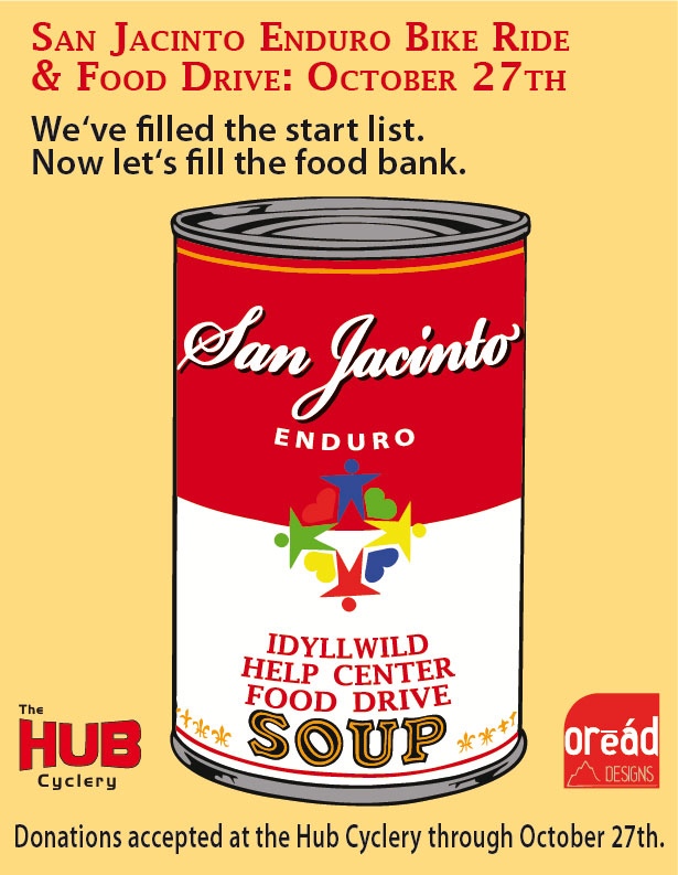
With so many of our friends coming from out of town next month to enjoy the riding in Idyllwild, we decided to take the opportunity to rally some off-trail awareness for a great local organization, the Idyllwild Help Center.

The Help Center provides services for more than 600 people, right here in Idyllwild. They operate a great thrift store and a food bank, in addition to providing several other great services. The food bank is low on stock right now, going into our Fall season. When I briefly talked with Colleen yesterday, it became clear right away that the cycling community can help.

We are setting a minimum goal to collect 250 food items with the SJ Enduro.
(truth be told, we’d really like to double that goal)

The Help Center appreciates any unopened, non-expired food donations. In particular, we would like to help with the following types:
– proteins (tuna, chicken, chili, etc)
– fruit
– soup

Bearing in mind the Enduro collects zero entry fee, we instead suggest a donation of the above items. Bring what you can spare to the start. One item, maybe five, it’s all appreciated.
The Hub Cyclery is setting up a food collection point and will be reaching out to the cycling community to help bolster the collection.

Together, we can help make Idyllwild an even better place to live and ride.

Start List is Full, Wait List is Up

We filled pretty darned fast this year.

20120917-065150.jpg

It took about 24 hours to fill up. Didn’t sign up in time? Don’t despair. We have a wait list started, and there aren’t many people on it yet.

Other info to know right now:
– In lieu of entry fees, which we never charge, we will suggest a donation of two cans of food. We are working with a local food bank on this, we will provide more detail soon.
– We still need to make a gpx track & cues for new first loop. The non-management’s calendar is kinda full right now, but has a non-managey day set aside for it on Oct 2nd. If’n any of you are available to knock it out before then, please let us know.
– We will host a pre-ride of the critical Singletrack section from the first loop, plus the entirety of the second loop on September 29th. Kinda like we did last year. Love connections and all, maybe.
– Seriously, get on that wait list if you weren’t one of the lucky callers. K?
– We will have an email list going out with all the pertinent info. Start time, location, camping info, all that stuff. That’ll come around the time of the new gpx file.

Enduro Start List is Open!

The start list is open!

20120915-145853.jpg

Click on over to the Enduro page to get yourself signed up.
The ride will probably fill very fast this year. Not sure you can make it? Please don’t sign up yet.
We want to fill the ride. There will be a no-show list published, as other self-supported rides are adopting. It’s the next best thing to tar & feathers. 😉

So on that note, the doors are open. Be nice. No Wal Mart riots please. See you on Oct 27th.

Enduro Route is Looking Good

The new & improved Enduro route is just about ready.

The first loop is getting some changes. It’s an even better route, albeit a little longer and yes, even harder. The changes are as follows:
-coming into Idyllwild, we will go up South Circle drive instead of Saunders Meadow.
-Tahquitz View
– South Ridge fire road
– South Ridge Singletrack, Traverse, down to May Valley rd.
– Log Pile/Snakeskin/Second Brother/Grindstone/Secret/Missing Link/Rage through the sage/Tunnel of Love

We need to redo the GPS track on the first loop.
Conditions are good. Most of the Thomas Mountain climb (and the Pole Line trail) were graded in June, and still looking good after the recent rains.
Morris Creek Singletrack is still chunky as ever.
The water flow at Cow Pie Spring is very weak. 😦
Ramona Trail is in great shape.

Once we redo the first loop GPS the route will come available. It’d be great to post the gpx file here… that’s an open solicitation for you tech heads to clue me in as to how to do that. 🙂

The 2012 San Jacinto Enduro is coming!

The 2012 San Jacinto Enduro is set for October 27th.

20120731-065245.jpg

Some early facts:
– We will be starting and ending in town, rather than at the campsite.
– The course is getting adjusted for the change of start location, along with some other course changes.
– Online sign up will be made available in early September on the Enduro page.
– Entries will be capped for a sub-50 rider field.

Results…

ARE UP!

SPOT Registration Reminder

Time to register your SPOT trackers!

Image

Go to the Trackleaders signup page to either register yours, or sign up to rent one. 
 

Final Route Announcement

The route is finalized & sittin’ pretty at 374 miles, 31k ft of climbing. 

The biggest, most notable difference between the early rough draft and the final route… no Salton Sea. The route was too long with that section, and we’ve got a fantastic diversity of terrain even without it. The new, final route features the mountains, desert, and ocean we’d set out to highlight in the first place. Oh, and we’re sitting at 80%+ dirt. Not too shabby.

We are tabulating the final cues now. In the mean time, view the route here on the leaderboard. An email with the route GPX will be landing in your inbox shortly. We’ll discuss the route in greater detail in the next post with cues attached. Get to studying!

What’s taking so long? A route change announcement

We’ve all been waiting patiently for the rest of the cues and the GPS track so we can start planning out the details of the ride. 

What’s taking so long?
We’ve changed up the route; essentially turning it from a counterclockwise loop to a clockwise loop. But that rabbit hole is a little deeper than that might sound.

How come it’ll be going the other way?
We want to offer up the best possible dirt touring route possible, with the best representation of our little slice of Southern California. Like one of those routes the Adventure Cycling Association has. In that vein, we will now get to ride Palm Canyon and later, Noble Canyon. Both are Southern California classics.

What are the practical differences?
The route is a bit harder, and a bit more mountain bike-y.
What had been climbs are now descents, and vice versa. The route will start with the “desert” section, which means at one point the route will take you from below sea level (Salton Sea) to nearly 4k ft on Pinyon Mountain, by way of some beautiful but sandy roads. (Fish Creek Wash in the Anza Borrego State Park) We will climb Oriflamme Canyon (the stuff of legend) into the Cuyamacas & Lagunas. The addition of these two singletracks and the reversal of Oriflamme & Fish Creek wash are the most significant changes your legs will notice.

Does this affect the mileage?
It might make the route a bit shorter, since we’ll descend from the San Jacintos further south.

So when will the route be set up and ready?
Soon. Promise! We’ve got 200 miles of the clockwise route mapped & cues’d, and need to get the reverse track set for the “first 117” you’ve already seen and some of the urban/San Diego Bay area. Hopefully the whole shebang will be done inside of two weeks.

We’ll be posting more info on the route, the cues, and SPOT registration here.